


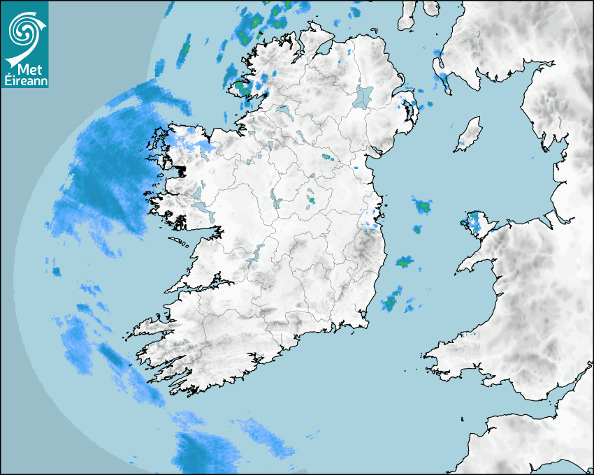

Latest Rainfall Radar showing live precipitation and the last 90 minutes precipitation over Ireland, updated every 5 minutes. Precipitation can be rain, hail or snow. Accumulations can refer to rainfall only.
Lightning strikes, when they occur, are displayed as a cross. Initially, they are red but change to orange and then yellow after a period, then disappear © Met Office ATDNet.
Ground Clutter may appear (South Co. Dublin), bright bands and spokes may also be present in images. They are artefacts (false echoes) of rainfall radar systems and should be ignored. Further information on Radar here
Met Éireann forecasters manually produce the weather icons for midday and midnight to reflect the predicted major weather type for these times.
The rainfall forecast is direct model output from Numerical Weather Prediction models but is a guideline only. Rain refers to precipitation, which can be rain, sleet or snow. It forecasts how much rain will fall (in mm) hourly during the previous hour (accumulations), then in 3 hourly and finally 6 hourly accumulations up to 7 days. This service is based on data and products of the HARMONIE-AROME and the European Centre for Medium-range Weather Forecasts (ECMWF) models.
The wind is direct model output from Numerical Weather Prediction models but is a guideline only. It forecasts the strength of the wind (in knots and km/h) at 10m for the top of each hour, in hourly, then 3 hourly and finally 6 hourly intervals up to 7 days. The wind arrow tip points in the direction the wind is blowing and the tail length indicates wind strength. However, in the text forecast below, it is described as where it is blowing from. This service is based on data and products of the HARMONIE-AROME and the European Centre for Medium-range Weather Forecasts (ECMWF) models.
The temperature is direct model output from Numerical Weather Prediction models but is a guideline only. It forecasts air temperature on land and over sea in °C for the top of each hour, 3 hourly and finally 6 hourly intervals up to 7 days. Minus zero (-0) indicates values between 0 to -0.5°C. This service is based on data and products of the HARMONIE-AROME and the European Centre for Medium-range Weather Forecasts (ECMWF) models.
The Mean Sea Level Pressure (MSLP) is direct model output from Numerical Weather Prediction models but is a guideline only. It forecasts the MSLP in hecto Pascals (hPa) for the top of that hour initially in 3 hourly intervals, then 6 hourly. This service is based on data and products of the HARMONIE-AROME and the European Centre for Medium-range Weather Forecasts (ECMWF) models.
National Forecast
26 July 2025 19:24
Today
Turning cloudy this evening with light patchy rain and drizzle moving into Altanic coasts. Largely dry elsewhere, apart from some isolated showers mainly over east Leinster and east Ulster. Mostly moderate westerly winds but fresh at times in the northwest.
Tonight
Tonight, will start off largely dry with just isolated showers. However, cloud will continue to build through the night with outbreaks of rain moving to northwestern and northern counties. Lowest temperatures of 10 to 14 degrees with light to moderate westerly winds.
Tomorrow
Sunday will be mostly cloudy with scattered showers extending from the west, through the morning, heavy at times in the north with some longer spells of rain possible. Further showers in the afternoon, but some bright or sunny intervals also. Highest temperatures of 16 to 21 degrees with mostly moderate westerly winds.
Regional Forecast - Dublin
26 July 2025 16:30
Today
A mix of cloud and sunny spells for the rest of today in light to moderate westerly winds. Mainly dry with well scattered showers dying out.
Solar UV Index
Moderate. High in sunshine on Sunday and Monday.
Tonight
Largely dry tonight with just isolated showers. Clear spells for a time but cloud will build from the northwest overnight. Lowest temperatures of 10 to 14 Celsius in mostly light west to southwest winds.
Tomorrow
Some sunny spells on Sunday but there will a good deal of cloud about overall with scattered showers spreading from the northwest. The showers will largely die out in the evening. Top temperatures of 17 to 20 Celsius in mostly moderate westerly winds.
Met News

02nd July 2025
Climate Statement for June 2025
4th warmest June on record, wet and dull for most ... more


05th June 2025
Climate Statement for Spring 2025
Ireland records highest average temperature and ho... more

04th June 2025
Climate Statement for May 2025
Warm, dry, calm and very sunny May for Ireland I... more